Detailed Orthomosaic Mapping
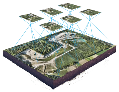
High resolution, georeferenced aerial mapping
- We create detailed, accurate aerial maps by stitching hundreds of drone images together.
Accurate measurements you can rely on
- Easily measure acreage, distances, fence lines, roads, and other key features.
Clear view of your land’s layout and improvements
- See roads, fencing, water sources, tanks, and structures in high detail.
Useful for management and marketing
- Ideal for ranch planning, property evaluation, and real estate listings.
Easy-to-share digital files
- Receive high-resolution maps in formats that are simple to view and share.
Agricultural Management with Multispectral IMAGING

Early Disease Detection
- Multispectral imaging reveals plant health issues that aren’t visible to the naked eye, including early signs of disease, nutrient deficiencies, and pest pressure.
Precision Farming
- Get detailed insights into plant health across your fields so you can apply fertilizer, water, and treatments only where they’re needed.
Water Management
- Identify areas of water stress and optimize irrigation to improve plant health while conserving water.
Canopy Management
- Multispectral imaging provides useful information about plant density and structure, helping you better understand growth patterns and overall crop condition.
Yield Estimation
- Track crop development throughout the season to support better planning and more informed management decisions.
Data-Driven Decision Making
- Turn aerial data into clear, actionable information that helps you manage your land more efficiently.
Why use drones?

Versatility
Cost-Effectiveness
Versatility
Equipped with various sensors, drones capture different types of data such as high-resolution imagery and multispectral imaging, tailored to your needs.
Efficiency
Cost-Effectiveness
Versatility
Drones cover large areas quickly and cost-effectively, providing timely data for agricultural management decisions.
Cost-Effectiveness
Cost-Effectiveness
Cost-Effectiveness
Compared to traditional methods, drones are a more affordable solution for aerial data collection, accessible to operations of all scales.
Vegetation Index Maps
Available Index Maps

Incorporating NDVI mapping into agricultural management practices empowers clients to make informed decisions, maximize yields, and ensure the long-term health and sustainability of their farm.